Stormy Easter weekend on tap?
Volatile Spring weather is here. During the day on Wednesday, expect south winds to strengthen with gusts of 30 to 40 mph possible. Very warm and breezy conditions are forecast on Thursday, with a high in the mid 90s.
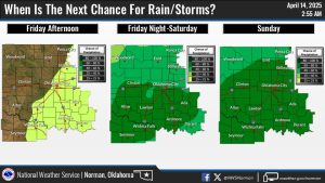
Multiple rounds of showers and thunderstorms are expected, beginning late Friday and over the weekend. Thunderstorms which lead to heavy rainfall and potential for flash flooding. Showers and thunderstorms are likely over the weekend as a strong trough approaches the southern plains.

Today
Increasing clouds, with a high near 75. North northeast wind 17 to 23 mph, with gusts as high as 34 mph.
Tonight
Cloudy, then gradually becoming partly cloudy, with a low around 48. Northeast wind 8 to 13 mph, with gusts as high as 20 mph.
Tuesday
Sunny, with a high near 74. North northeast wind 5 to 10 mph becoming east southeast in the afternoon.
Tuesday Night
Mostly clear, with a low around 50. Southeast wind 7 to 10 mph.
Wednesday
Sunny, with a high near 85. South wind 7 to 12 mph increasing to 15 to 20 mph in the afternoon. Winds could gust as high as 30 mph.
Wednesday Night
Mostly clear, with a low around 63.
Thursday
Sunny, with a high near 95.
Thursday Night
Partly cloudy, with a low around 66.
Friday
Partly sunny, with a high near 87. 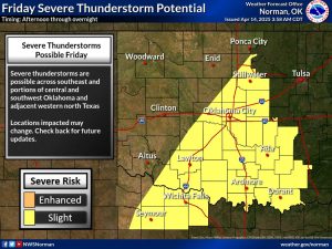
Friday Night
A chance of showers and thunderstorms, then showers likely and possibly a thunderstorm after 1am. Mostly cloudy, with a low around 55. Chance of precipitation is 60%.
Saturday
A 50 percent chance of showers and thunderstorms. Partly sunny, with a high near 77.
Saturday Night
Showers likely and possibly a thunderstorm. Mostly cloudy, with a low around 54. Chance of precipitation is 70%.
Sunday
A 50 percent chance of showers and thunderstorms. Partly sunny, with a high near 75.