This hazardous weather outlook is for portions of northern...western...central...and southern Oklahoma...and western north Texas.
.DAY ONE...Today and Tonight...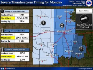 .SPOTTER AND EMERGENCY MANAGEMENT STATEMENT...
Storm spotter groups and emergency management personnel across our Oklahoma and western north Texas should prepare for severe
.SPOTTER AND EMERGENCY MANAGEMENT STATEMENT...
Storm spotter groups and emergency management personnel across our Oklahoma and western north Texas should prepare for severe 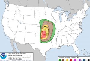 weather operations this afternoon and evening.
.Thunderstorms...
A significant severe weather outbreak, with potentially two rounds, is expected to impact Oklahoma and potentially westernnorth Texas this afternoon and through the evening and result in
strong, long-lived tornadoes, very large to giant hail two to four inches in diameter, and damaging wind gusts 80 mph or more.
Explosive thunderstorm development is likely to begin mid-afternoon to early evening over western Oklahoma, with some potential for an initial round of tornadic supercells to affect
the I-35 corridor near rush hour.
.Excessive Rainfall...
weather operations this afternoon and evening.
.Thunderstorms...
A significant severe weather outbreak, with potentially two rounds, is expected to impact Oklahoma and potentially westernnorth Texas this afternoon and through the evening and result in
strong, long-lived tornadoes, very large to giant hail two to four inches in diameter, and damaging wind gusts 80 mph or more.
Explosive thunderstorm development is likely to begin mid-afternoon to early evening over western Oklahoma, with some potential for an initial round of tornadic supercells to affect
the I-35 corridor near rush hour.
.Excessive Rainfall...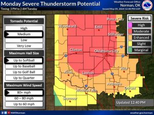 Long-lived severe thunderstorms could produce rainfall amounts of two to four inches, with locally higher amounts possible.
Excessive rainfall could lead to flash flooding this afternoon and into tonight.
Long-lived severe thunderstorms could produce rainfall amounts of two to four inches, with locally higher amounts possible.
Excessive rainfall could lead to flash flooding this afternoon and into tonight.