Bitter cold, wintry mix on tap
Breezy winds continuing overnight Saturday will give way to single digit to low teen wind chill values across the western half of Oklahoma and western north Texas. Temperatures will briefly warm Sunday under mostly sunny skies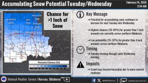
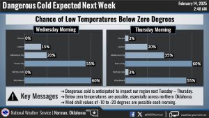
Monday will feature a brief warm up under weak ridging ahead of the next system. The upper low pivoting over Canada that brought the shortwave Saturday will bring yet another shortwave trough Tuesday. A strong cold front Tuesday will bring breezy winds and frigid air by Wednesday morning with wind chill values near -10 to -20 degrees. This cold airmass will be reinforced by another shortwave trough axis following in the wake of Tuesday`s system. Thus very cold temperatures and dangerously cold wind chills will remain through Thursday. In addition to the cold airmass, Tuesday`s system will bring increased precipitation chances. Any precipitation ahead and along the frontal boundary may start in the form of rain/freezing rain, but will quickly transition to snow with the deep cold airmass following not far behind.